Posts

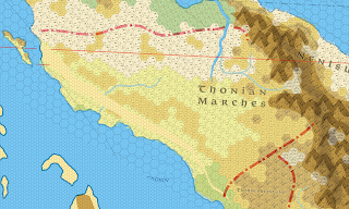
Ochalea - 8 miles per hex

Image
This wasn't originally going to be the next map I put out there, but as I'm (very) slowly reworking the Isle of Dawn, I thought I would finalize this. As I have mentioned before, the Isle of Dawn is re-scaled from the original. This allows it to fit correctly in the space on the map from the Master's book, without pushing the surrounding islands into other landmasses.  However, this also means that a decision needed to be made about scaling and positioning of Ochalea (and also the Alatian and Pearl Islands).  After a lot a of messing around, I decided to work with not re-scaling these but adjusting the positions of the island groups relative to each other. Ochalea itself is based on work by Thorfinn Tait, James Mishler, John Calvin, Giampaolo Agosta. The southern areas of the Isle of Dawn are based on work by Thoirfinn Tait, Simone Neri, Ignacio Ramos, Thibault Sarlat. ( Link to full size image ) Also, for those that are interested, I've added a scaled down version o...

The Empire of Thonia

Image
I've been thinking recently about Thonia, and its place in modern Mystara. Firstly, I wanted to get a feel for it in the context of mapping it in the 8 miles per hex format, linked to the more general adjustments to rotation and scaling I have been working on.  This is intended to bring everything into line/scale with the map from the inside cover of the Master's set. Recently, Thorf kindly produced a version on this Master's set map which had an overlay hex grid of 24 miles per hex.  Also, importantly, this was rotated to align with the map of Brun from the companion set, and therefore the Gazetteer and Trail Maps. To create the basic coastlines, and general topography, I referenced this map, and overlaid with his earlier map of Skothar at 72 miles per hex.  As can be seen on the below outline, there is a slight "tear" to adjust a discontinuity between the two.   (Link) Secondly, I am viewing this as a "points of light" style campaign setting.  Thonia i...

The Forest Jen

This is something I've been knocking around for a while, and thought I would finally put it down Quite large scale, based off Thorf's 72 mile map of Skothar,  The Forest Jen In the Master's map, the Jen are to the north-east of Esterhold, and then to the south-east is the "Empire of the Great Khan".  When you look at the planetary map in the HW boxed set, the "Steppes of Jen" replace the "Empire of the Great Khan", and the area to the north-east of Esterhold is forested, and separated from the steppes by a mountain chain. This made me think, what if both are true?  And what if the refugees from the Alphatian invasion had migrated to the forest area.  And who was there before? Forest Jen When the Alphatians invaded Esterhold, some fled to the south-east steppes, but others fled to the heavily forested valley of the River Chisdiq.  These Jen adopted a semi-nomadic lifestyle suitable for their new home, small clans moving their villages from one s...

Known World (Reworked)

Image
 It has been a while, but what with lock down, and a fundamental reevaluation of how I was looking at this, I have now redone the Known World. There are some minor changes to the artwork, but primarily, I have been trying to correct the 8 mile per hex maps to the 1985 companion map of Brun and after that the world map from the cover of the Master DM's book. For this map, the differences are relatively minimal, but this does include rotating Norwold by 1 degree and rescaling the Isle of Dawn by 92.5%. In addition the Gazetteers and Trail Maps, I've utilized a large number of fan maps, including those of Thorfinn (all over), John Calvin (Sea of Dread and Ochalea), JTR (Denagoth, Heldann, Landfall) and Geoff Gander (Heldann and Northern Wildlands) Known World (Reworked)  - High resolution version

Threshold

Image
Threshold, the classic starting point for many a first foray into the Known World.  This has been sat around on my hard drive for a while, almost, but not quite finished.  Based on the map in B1-9. Much of the early work was done trying to understand how to use paint.net as flexibly as it can be.

Known World at 8mph

Image
It's been a while, but finally the draft of the Known World at 8 mph is now complete. Known World 8mph Sources: TM1, TM2, Gazetteers, PC3, X8 Thorfinn Tait (Atruaghin, Sind, Wendar) Old Dawg (Heldann) To do:  Adri Varma South to Isle of Dread Conversion to 24 & 72 mph.

Karameikos

Image
As everyone seems to start with Karameikos, here it is... Hopefully I'll be able to keep up a reasonable schedule using this new method.  It seems to be relatively stable doing it this way, so will hopefully have fewer issues. Next up is to workout how to convert these to 24 and then 72 mile per hex maps.  I'm pretty certain it can be done and made to look good, but actually doing it is another matter entirely.