The Empire of Thonia
I've been thinking recently about Thonia, and its place in modern Mystara.
Firstly, I wanted to get a feel for it in the context of mapping it in the 8 miles per hex format, linked to the more general adjustments to rotation and scaling I have been working on. This is intended to bring everything into line/scale with the map from the inside cover of the Master's set.
Recently, Thorf kindly produced a version on this Master's set map which had an overlay hex grid of 24 miles per hex. Also, importantly, this was rotated to align with the map of Brun from the companion set, and therefore the Gazetteer and Trail Maps.
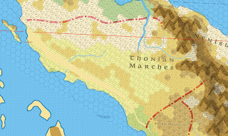
To create the basic coastlines, and general topography, I referenced this map, and overlaid with his earlier map of Skothar at 72 miles per hex. As can be seen on the below outline, there is a slight "tear" to adjust a discontinuity between the two.
(Link)
Secondly, I am viewing this as a "points of light" style campaign setting. Thonia is a dying Empire, the citizens cowering in fortified towns and cities. The lands between are rife with humanoid tribes, lycanthropes, undead, entropic cultists, unseelie fey and other worse creatures. But these lands also hide ancient tombs from the glory days of Thonia, hidden wizard towers, ancient Blackmoor technomagic, that may still be running.
What there is of a central government is corrupt, and the remaining ten Dukes are more interested in jockeying for power in the capital than actually ruling their domains.
So here is the draft map at 24 miles per hex.
(Link)
In time, I will expand on the regions and history.


Comments
Post a Comment