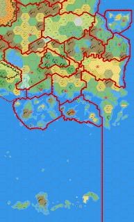
I first came across the inconsistencies in the maps of the Heldann Freeholds back in the early 90's when trying to link the X1 map of the Known World to the map in X11. Now that I've reached that point again, I thought it appropriate to revisit this. As the basis of this project is to build up from the 8 mile per hex maps, using the Gazetteer and Trail Maps as the "base layer", and building up from there using other sources, this is the approach used here. In the below outline, the dark blue and red indicate the coast and borders from TM2. Unfortunately we can only go just south of Freiburg with this map, so overlaid on this are the 24 (mid blue and brown) and 48 (light blue and pink) mile per hex maps from WoTI. These maps are lined up on the small bay on the Vestland/Heldann border and in the southern portion these are a reasonably good fit. However north of where the 8 mile map finishes, the two other maps diverge, with the position of the Naga (Elber...